A powerful typhoon has lashed the Philippines and is now churning towards Taiwan, prompting warnings and flight cancellations.
Krathon has been upgraded to a strong typhoon, with sustained winds reaching up to 175 kmph (109 mph) and gusts as high as 215 kmph (133 mph).
The slow-moving storm was blowing westward and could strengthen into a super typhoon when it veers northeastward on Tuesday towards Taiwan.
Taiwan issued a land warning this morning as forecasters warned the storm is expected to cross the island’s densely populated west coast, including the major port city of Kaohsiung, bringing torrential rain and strong winds.
“The impact is getting bigger and bigger,” said Gene Huang, forecaster at the CWA, pointing to threats to Taiwan’s southwest and adding it was “rare” for such a powerful typhoon to make a direct hit on the island’s western plains.
The storm has already lashed the northernmost islands of the Philippines, prompting officials to evacuate hundreds of villagers, shut down schools and inter-island ferries and warn of “potentially very destructive” rainfall in the region.
Key Points
-
Typhoon Krathon lashes Philippines with ‘very destructive’ rainfall
-
Typhoon Krathon set to make rare landfall on Taiwan’s populated west coast
-
Typhoon Krathon tracker: Path and forecast
-
Typhoon Krathon forecast: Storm to hit Taiwan’s populated west coast
-
Hong Kong set to experience extreme heat amid Typhoon Krathon
Map: Typhoon Krathon continues to intensify as it moves closer to Taiwan
13:30 , Stuti Mishra
Typhoon Krathon is continuing to intensify as it churns towars Taiwan.
The storm is currently located approximately 260 kilometres southeast of Taiwan’s southernmost point, Cape Eluanbi.
It is slowly moving west-northwest at 5 kmph, with maximum sustained winds of 213 kmph and gusts up to 260 kmph, making it close to a Category 4 hurricane.
Krathon’s approach is causing heavy rainfall and dangerous conditions across Taiwan’s eastern and southern regions.


Typhoon Krathon: Eastern Taiwan sees heavy rain and landslides
13:00 , Stuti Mishra
As Typhoon Krathon inches closer to Taiwan, eastern regions have already begun to experience its impact.
From last night, heavy rainfall has been battering the area, causing landslides along Provincial Highway No 9, disrupting traffic between Su’ao in Yilan County and Chongde in Hualien, Focus Taiwan reported.
Several vehicles were trapped near Huide Tunnel, though no injuries were reported.
All stranded individuals were successfully rescued, and the blocked sections of the highway were closed as a precaution.
The Central Weather Administration (CWA) has issued heavy rain alerts for Taiwan’s eastern counties, with rainfall expected to exceed 80 mm within 24 hours.
Taiwan’s national parks, beaches, and ferry services have also been suspended as safety measures. Transportation between Hualien and Taitung, along with sections of the South Link Line, has been halted due to the storm’s progression.
Krathon is expected to make landfall on Taiwan’s southern coast tomorrow, with strong winds and torrential rain likely to affect the island through Thursday.
Philippines: People wade through flooded streets
12:30 , Stuti Mishra




Photos: Staff stock canned food at supermarkets in Taipei ahead of Typhoon Krathon
12:00 , Stuti Mishra


Over 500 people evacuated from Kaohsiung ahead of Typhoon Krathon
11:30 , Stuti Mishra
As Typhoon Krathon approaches Taiwan, 521 people have been evacuated from the mountainous regions of Kaohsiung today in anticipation of severe weather.
Local authorities issued landslide warnings for the districts of Taoyuan, Maolin, Namasia, and Liugui, prompting evacuations.
Kaohsiung mayor Chen Chi-mai inspected disaster preparedness measures, including flood control systems and the city’s 91 pumping stations, Taiwan News reported.
Kaohsiung is bracing for heavy rainfall, with estimates suggesting up to 800 mm in the mountainous areas.
Schools were moved online and 23,000 sandbags have been distributed across the city to help residents prepare for flooding.
Forecast animation shows path of Typhoon Krathon
11:06 , Stuti Mishra
A forecast animation from Zoom Earth, a privately-run weather tracker, shows Typhoon Krathon’s projected path as it heads toward southern Taiwan.
The animation shows the typhoon’s intense wind gusts and possible landfall near Kaohsiung, with winds expected to exceed 200 kmph.
However, the storm’s interaction with Taiwan’s mountainous terrain could lead to unpredictable changes in its direction, making the exact landfall location difficult to forecast.
A very powerful typhoon could strike southern #Taiwan on Wednesday, bringing winds over 200 km/h and extreme rainfall ⚠️
Typhoon #Krathon’s exact landfall location will be difficult to forecast.
As the typhoon interacts with the high mountains of Taiwan, its motion could become… pic.twitter.com/gUoBdboGxZ
— Zoom Earth (@zoom_earth) September 30, 2024
Satellite image shows Typhoon Krathon’s intensity
10:40 , Stuti Mishra
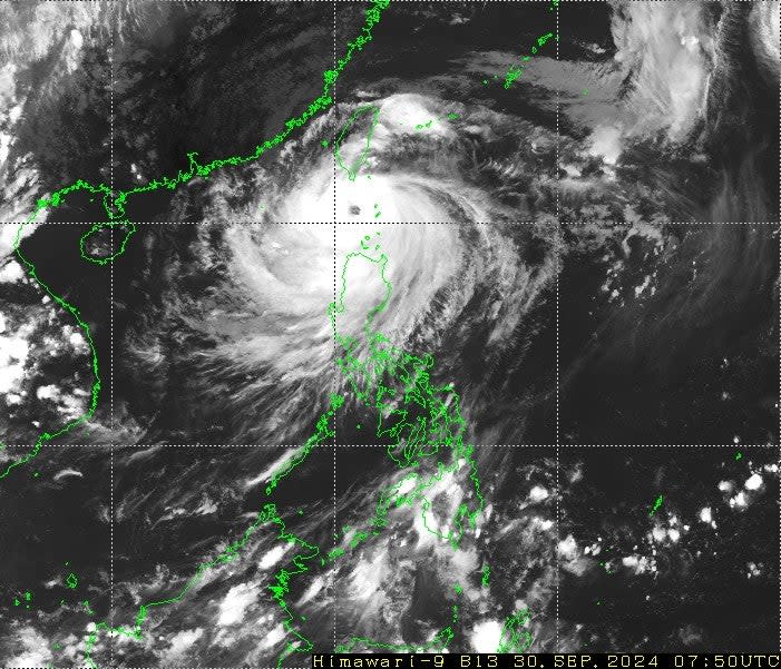
A satellite image taken from Japan’s Himawari-9 a while back shows Typhoon Krathon swirling over the Luzon Strait, between the Philippines and Taiwan.
The well-defined eye and dense cloud bands show that Krathon has grown in strength, as it moves northwest toward Taiwan.
The typhoon’s spiral structure is clear, with intense thunderstorms surrounding the eye, a hallmark of a strong storm.

Video: Philippine Coast Guard tows stranded speedboat amid Typhoon Krathon
10:20 , Stuti Mishra
Travel disruptions and closures due to Typhoon Krathon
10:00 , Stuti Mishra
Coastal and national park areas have been closed in Taiwan as a precaution, and ferry services have been suspended across several regions.
The rail line connecting southern Taiwan to the east coast was halted on Monday afternoon due to the storm, though the north-south high-speed railway continues to operate as normal.
Despite the disruptions, international flights from Taipei have not yet been affected, according to the transport ministry.
Typhoon Krathon forecast: Storm to hit Taiwan’s populated west coast
09:40 , Stuti Mishra
Taiwan’s Central Weather Administration (CWA) has issued a warning for the western and southern regions of the country as Typhoon Krathon approaches.
Extremely heavy rainfall, potentially exceeding 200 mm in 24 hours, is expected in areas such as Hualien, Taitung, Orchid Island, and Green Island.
Heavy rain warnings have also been extended to other areas, including Yilan County and mountainous regions of Taipei, New Taipei, and the port city of Kaohsiung.
Authorities have deployed thousands of soldiers and rubber boats to southern and eastern Taiwan, anticipating potential flooding and landslides.
Hong Kong set to experience extreme heat amid Typhoon Krathon
09:20 , Stuti Mishra
Hong Kong is set to experience scorching temperatures today and tomorrow as Typhoon Krathon approaches southern Taiwan.
Though the storm is not expected to directly affect Hong Kong, the city will feel the heat due to the typhoon’s outer subsiding air, causing temperatures to soar across southern China, according to the Hong Kong Observatory.
Despite Krathon remaining over 500 kilometres from Hong Kong, residents were advised to stay hydrated and take precautions against the heat on these very hot days.
Video: Rain and winds pick up in Taipei
09:00 , Stuti Mishra
Rain and winds are starting to pickup in taipei it’s empty streets. Already warning issued for super Typhoon krathon landing by central weather administration , schools and flights canceled. pic.twitter.com/9zmJVPNFiL
— Tashi (@hopefulhumanist) September 30, 2024
Photos: Taiwan braces for Typhoon Krathon
08:45 , Stuti Mishra




Typhoon Krathon tracker: Path and forecast
08:23 , Stuti Mishra
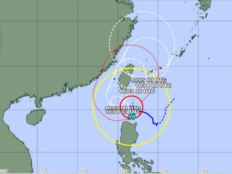
Typhoon Krathon is currently tracking west-northwest toward Taiwan after impacting the northern Philippines.
Krathon is classified as a “very strong” typhoon, with maximum sustained winds near the centre reaching 185 kmph and gusts of up to 260 kmph, according to the latest updates from the Japan Meteorological Agency (JMA) and Taiwan’s Central Weather Administration (CWA).
Currently located approximately 430 kilometres southeast of Taiwan’s southernmost point, Oluanpi, the typhoon is moving west-northwest at a slow speed of around 10 kmph.
Krathon is expected to continue moving westward before turning slightly northwest and making landfall near Kaohsiung, Taiwan, by late night tomorrow or early morning on Wednesday. Winds are expected to reach up to 185 kmph (115 mph) near the centre, equivalent to a Category 4 hurricane on the Saffir-Simpson scale.
Following landfall, Krathon is forecast to move across southern Taiwan, bringing heavy rainfall, intense winds, and a high risk of flooding.

Typhoon Krathon set to make rare landfall on Taiwan’s populated west coast
08:16 , Stuti Mishra
Typhoon Krathon, a powerful storm that has already lashed the northern Philippines, is now heading toward Taiwan, bringing the potential for destructive winds, torrential rains, and severe flooding.
The Japan Meteorological Agency (JMA) has classified Krathon as a “very strong” typhoon with sustained winds of 95 knots (109 mph) and gusts of up to 135 knots (155 mph).
It is expected to strengthen further as it approaches Taiwan’s heavily populated western coast tomorrow.
Taiwan’s Central Weather Administration (CWA) has issued land and sea warnings as the typhoon draws closer.
The storm is forecast to make landfall near Kaohsiung, Taiwan’s major southern port city, late Tuesday or early Wednesday.
“The impact is getting bigger and bigger,” said Gene Huang, forecaster at the CWA, pointing to threats to Taiwan’s southwest and adding it was “rare” for such a powerful typhoon to make a direct hit on the island’s western plains.
Typhoon Krathon lashes Philippines
08:00 , Stuti Mishra
Typhoon Krathon, locally known as Typhoon Julian, has battered the northernmost islands of the Philippines, prompting widespread evacuations and warnings of potential devastation to coastal communities.
The powerful storm, with sustained winds of up to 109 mph and gusts reaching 133 mph, was last located near Balintang Island, off the provinces of Cagayan and Batanes, according to the Philippine weather bureau PAGASA.
The slow-moving typhoon is expected to strengthen further, potentially reaching super typhoon status as it turns northeast towards Taiwan tomorrow.
Although no casualties or significant damage have been reported so far, officials remain on high alert as the storm poses a significant threat to lives and infrastructure.
Hundreds of villagers were evacuated, schools were shut down shut down schools and inter-island ferries were closed.
PAGASA has issued warnings of a “moderate to high risk of life-threatening storm surges” along the coastal areas of Batanes, Babuyan Islands, and Cagayan province.
“The situation is potentially very destructive to the community,” it said.
07:48 , Stuti Mishra
Welcome to The Independent’s liveblog on Typhoon Krathon. Follow for the latest updates from the Philippines and Tawain.
